
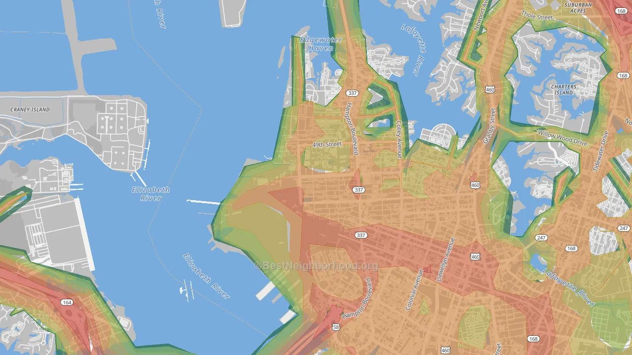
This map shows modeled outdoor noise across Lamberts Point at 100-meter resolution, combining road, aviation, and rail sources. Green areas measure below 45 dBA. Orange and red exceed the EPA's 55 dBA outdoor threshold linked to long-term health effects. Use the layer toggles to view each source on its own or all together.
What the numbers sound like
- 30 dBAWhisper
- 40 dBASoft rainfall
- 45 dBAQuiet suburban street at night
- 50 dBAQuiet office
- 55 dBAEPA outdoor threshold: light traffic 100 ft away
- 60 dBANormal conversation an arm's length away
- 65 dBABusy restaurant
- 70 dBAHighway traffic 50 ft away
- 80 dBACity bus interior
Population Above the EPA Outdoor Threshold
The EPA's 55 dBA outdoor reference level is a common benchmark for residential noise exposure, especially for activity interference, annoyance, and long-term community noise concerns. About 2,445 Lamberts Point residents, or 64.1%, live above that level. By land area, 83.1% of Lamberts Point is above 55 dBA.
See how noise in Lamberts Point compares to similar-sized neighborhoods.
Noise by Part of Lamberts Point
Average noise levels for Lamberts Point residents, grouped by direction from the center of Lamberts Point. The highest population-weighted average is in southeastern Lamberts Point; the lowest is in northwestern Lamberts Point, where just 51% of residents live in blocks above the EPA's 55 dBA threshold, about two-thirds of the share in the loudest section.
Southeastern Lamberts Point
89% of people above 55 dBA
Central Lamberts Point
64% of people above 55 dBA
Eastern Lamberts Point
51% of people above 55 dBA
Northwestern Lamberts Point
51% of people above 55 dBA
To the human ear, noise in southeastern Lamberts Point sounds about 8% louder than in northwestern Lamberts Point, a 1.1 dBA gap. Every 10 dBA roughly doubles perceived loudness. Within any of these directions, two homes a quarter mile apart can still differ by 10 or more dBA depending on how close they sit to a major highway.
Rail Noise
Active freight rail runs through parts of Lamberts Point. For most blocks the rail-only contribution is small. Combined road-plus-rail noise rarely exceeds road noise on its own. The exceptions are the handful of blocks within roughly a quarter mile of the right-of-way during pass-through hours.
Use the Rail toggle on the map above to isolate rail's contribution from road and aviation.
Airport Noise
Norfolk International (ORF) sits east of Lamberts Point. The U.S. Department of Transportation models aviation noise around this airport from federal traffic data, and the model uses those federal measurements rather than synthetic predictions.
Blocks under the approach and departure paths carry combined road-plus-aviation noise, with some exceeding 65 dBA on the map's Overall layer. Blocks on the opposite side of Lamberts Point, particularly to the west, show no measurable aviation contribution. Use the Aviation toggle on the map above to isolate the airport's footprint.
How Noise Is Distributed Across Lamberts Point
The bar chart below shows the share of Lamberts Point residents in each noise band. About 3% of residents live below the EPA's 55 dBA threshold, and roughly 11% live in blocks above 60 dBA. Long-term exposure in that range is linked to elevated stress hormones and cardiovascular risk.
How Lamberts Point Compares
Lamberts Point sits at the louder end of the spectrum. Below: how Lamberts Point's average outdoor noise and share of residents above the EPA threshold compare with Ballentine Place, Fairmont Park, Highland Park, and Central Brambleton.
Average noise level (dBA)
Lamberts Point's 57.3 dBA pop-weighted average is at the louder end of the spectrum. Virginia as a whole averages 52.8 dBA and the U.S. averages 52.0 dBA. Both are lower than Lamberts Point because most of either area is rural land away from major roads.
Share of residents above 55 dBA
About 64.1% of Lamberts Point residents live in blocks where outdoor levels exceed the EPA's 55 dBA threshold. That's more than any of its peer group. Measured by land area instead, 83.1% of Lamberts Point's footprint sits above 55 dBA, against a Virginia average of 30.0% and a national average of 28.1%.
What This Means if You're Moving to Lamberts Point
- Distance from highways matters more than the neighborhood name. Two homes in the same zip code can differ by 20 dBA if one sits 100 meters from and the other 500 meters away. The model captures this at 100-meter resolution, so noise exposure changes block by block.
- Tree canopy can help reduce modeled noise exposure. Roughly 15% of Lamberts Point is under tree cover (about average for neighborhoods), and the dominant land cover is medium-intensity developed land. Both are measured from federal USDA Forest Service and USGS satellite imagery at 30-meter resolution. Streets with 60% or higher canopy show 3 to 5 dBA lower noise than comparable streets with bare ground or pavement, which is why the per-place decay rate above already accounts for it.
- Airport noise is directional. Norfolk International's approach paths concentrate aviation noise to the east. Neighborhoods to the west of downtown show no measurable contribution from the airport.
Sources & Methodology
The BestNeighborhood noise model is calibrated against nearly one million federal ground-truth measurements across four states. Road noise is computed from segment-level federal traffic data and propagated outward using physics-based acoustic decay, with attenuation rates that depend on the surrounding land cover.
Federal datasets used:
FHWA Highway Performance Monitoring System: road geometry, traffic counts, lane configuration
U.S. DoT Bureau of Transportation Statistics National Transportation Noise Map: aviation and rail noise, road calibration ground truth
USGS / MRLC National Land Cover Database: land cover and impervious surface coverage
USDA Forest Service Tree Canopy Cover: vegetation density for sound propagation
U.S. Census Bureau TIGER/Line: block-level geography and population
U.S. EPA Levels Document: 55 dBA outdoor reference level
All inputs are published federal datasets. Block-level noise is computed by combining road, rail, and aviation sound sources in the energy domain, the same physics used in professional environmental noise assessments. Read the full methodology.