
This page draws on the CDC PLACES dataset to summarize the health of adults in 76579, TX. The single biggest gap vs. the national average is Obesity. The share of adults living with obesity here is 24% above the U.S. average. The sections below explain that measure and compare all 40 measures with the U.S. average. The CDC PLACES 2025 release publishes 33 of its 40 measures for 76579, TX. The rest are marked as no data.
Top Health Metrics in 76579, TX
Four headline measures for adults in 76579, TX, each compared with the U.S. average. Green is better than the U.S., red is worse. In every bar the center line is the U.S. average and the dot is 76579, TX.
Local resources for 76579, TX
Data and tools from BestNeighborhood and our sister sites, all built on the same hyper-local rigor as the page you're on.
Obesity in 76579, TX
41.2% of adults living with obesity · 24% above the U.S. average
Obesity raises the risk of type 2 diabetes, heart disease, and stroke, according to CDC. CDC PLACES defines it as a body mass index of 30 or higher, from self-reported height and weight.
Adults Without Health Insurance in 76579, TX
13.7% of adults 18 to 64 without health insurance · 22% above the U.S. average
This measure counts adults ages 18 to 64 who report having no health insurance of any kind.
The Community Health Need Index across 76579, TX
The Community Health Need Index rolls up 39 CDC PLACES measures into one value per census tract, where 50 is the U.S. average and higher means more measured health need. Switch layers to see the overall index or any of its three components.
This is not a health score or a grade. It's a Community Health Need Index (CHNI), a needs assessment that combines three parts. Current health burden covers existing disease, mental-health symptoms, and disability. Preventable risk covers factors like smoking, inactivity, obesity, and high blood pressure. Access and barriers covers the ability to reach care, food, and support. On the 0 to 100 scale, 50 is the U.S. average. The index does not predict any individual's health or offer medical advice. Read the full CHNI methodology.
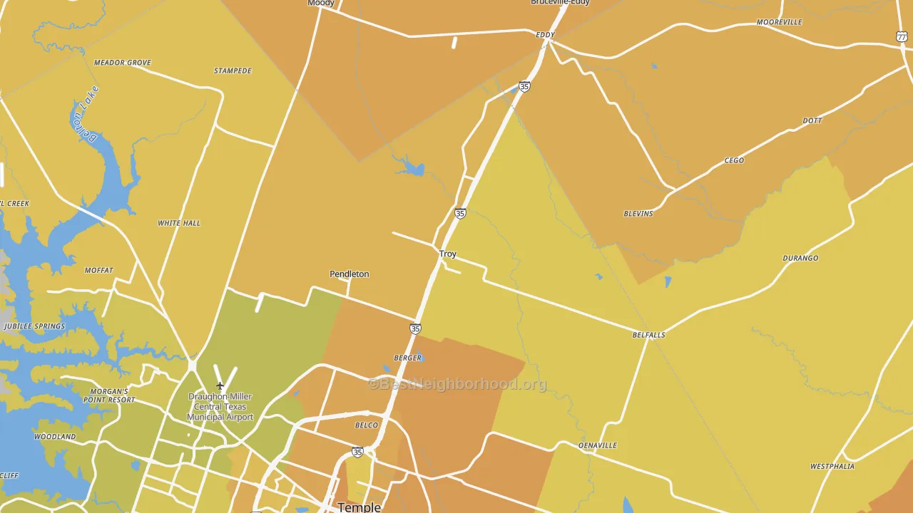
Health varies inside 76579, TX
CDC PLACES tracks these measures at the neighborhood level. Within 76579, TX, the list below shows where each measure runs highest and lowest.
- Diabetes Diagnosis peaks in Southwestern 76579, TX (13.8%) and is lowest in Central 76579, TX (11.8%), a 17% spread within the same ZIP code.
- Obesity peaks in Southwestern 76579, TX (43.3%) and is lowest in Eastern 76579, TX (38.6%), a 12% spread within the same ZIP code.
- Adult Smoking peaks in Northwestern 76579, TX (16.0%) and is lowest in Central 76579, TX (12.4%), a 29% spread within the same ZIP code.
- Physical Inactivity peaks in Southwestern 76579, TX (30.6%) and is lowest in Central 76579, TX (25.3%), a 21% spread within the same ZIP code.
- Annual Dental Visit peaks in Central 76579, TX (61.1%) and is lowest in Southwestern 76579, TX (55.4%), a 10% spread within the same ZIP code.
- Frequent Mental Distress peaks in Southwestern 76579, TX (19.0%) and is lowest in Central 76579, TX (16.8%), a 13% spread within the same ZIP code.
- Adults Without Health Insurance peaks in Southwestern 76579, TX (15.2%) and is lowest in Central 76579, TX (12.0%), a 27% spread within the same ZIP code.
All 40 CDC Community Health Measures
Every measure CDC tracks at the neighborhood level, comparing this place to the U.S. weighted average. Each value is the share of adults reporting the condition or behavior.
Long-term conditions adults live with day to day, from diabetes and heart disease to arthritis and cancer.
| Chronic Disease | Local | U.S. avg | Vs. U.S. |
|---|---|---|---|
| Diabetes Diagnosis | 12.9% | 11.9% | 8% worse |
| High Blood Pressure | 35.5% | 33.9% | About average |
| High Cholesterol | 35.6% | 36.0% | About average |
| Coronary Heart Disease | 6.6% | 6.1% | 8% worse |
| Stroke | 3.5% | 3.4% | About average |
| Cancer (Non-Skin) or Melanoma | 8.4% | 7.6% | 10% worse |
| COPD | 7.4% | 6.5% | 13% worse |
| Current Asthma | 10.6% | 10.4% | About average |
| Arthritis | 28.1% | 24.9% | 13% worse |
| Obesity | 41.2% | 33.4% | 24% worse |
| Depression | 26.2% | 21.9% | 19% worse |
Everyday habits that shape future health, like smoking, drinking, physical activity, and sleep.
| Health Behaviors | Local | U.S. avg | Vs. U.S. |
|---|---|---|---|
| Adult Smoking | 14.3% | 13.1% | 9% worse |
| Binge Drinking | 15.6% | 16.1% | About average |
| Physical Inactivity | 28.1% | 25.3% | 11% worse |
| Short Sleep Duration | 39.6% | 36.5% | 9% worse |
Screenings and routine visits that catch problems early. Higher shares are better here.
| Preventive Care | Local | U.S. avg | Vs. U.S. |
|---|---|---|---|
| Annual Doctor Visit | 76.7% | 76.6% | About average |
| Cholesterol Screening | 86.4% | 85.8% | About average |
| Colorectal Cancer Screening | 64.2% | 63.9% | About average |
| Mammography Screening | 75.3% | 75.8% | About average |
| Annual Dental Visit | 57.9% | 61.3% | 6% worse |
| Taking Blood Pressure Medication | 76.0% | 74.3% | About average |
How adults rate their own physical and mental health, plus related quality-of-life measures.
| Health Status | Local | U.S. avg | Vs. U.S. |
|---|---|---|---|
| Fair or Poor General Health | 21.4% | 20.1% | 6% worse |
| Frequent Physical Distress | 14.7% | 13.5% | 9% worse |
| Frequent Mental Distress | 18.0% | 16.8% | 7% worse |
| All Teeth Lost (Adults 65+) | 14.3% | 13.2% | 8% worse |
The share of adults living with difficulty in mobility, cognition, hearing, vision, or self-care.
| Disability | Local | U.S. avg | Vs. U.S. |
|---|---|---|---|
| Any Disability | 34.3% | 30.6% | 12% worse |
| Mobility Limitation | 15.6% | 13.9% | 12% worse |
| Cognitive Limitation | 15.6% | 14.7% | 6% worse |
| Hearing Limitation | 7.5% | 6.6% | 14% worse |
| Vision Limitation | 5.3% | 5.6% | 6% better |
| Self-Care Limitation | 4.0% | 4.0% | About average |
| Independent Living Limitation | 8.5% | 8.4% | About average |
Insurance, food, housing, transportation, and support. These conditions decide whether residents can reach care.
| Access & Social Drivers | Local | U.S. avg | Vs. U.S. |
|---|---|---|---|
| Adults Without Health Insurance | 13.7% | 11.3% | 22% worse |
| Loneliness | n/a | 34.4% | No data |
| Lack of Social and Emotional Support | n/a | 24.8% | No data |
| Food Insecurity | n/a | 17.1% | No data |
| SNAP Receipt | n/a | 14.3% | No data |
| Housing Insecurity | n/a | 13.8% | No data |
| Utility Shut-Off Threat | n/a | 8.8% | No data |
| Lack of Reliable Transportation | n/a | 9.1% | No data |
Healthcare near 76579, TX
Access to good healthcare is inseparable from the metrics on this page. Below are the closest hospital and pharmacy, plus the top-rated Medicare plan available in this area. Hospital data comes from CMS Care Compare, pharmacy data from the CMS NPI Registry, and Medicare plan data from CMS Medicare Plan Finder, all aggregated by our sister site InsuranceDataNow.
Nearest Hospital
Baylor Scott & White Medical Center - Temple, 9.5 mi away
2401 S 31st St Temple, TX 76508
Nearest Pharmacy
H-E-B, Lp, 7.8 mi away
1314 W Adams Ave Temple, TX 76504
GoodRx lists prescription prices at nearby pharmacies. The GoodRx link is an affiliate link.
Top-Rated Medicare Plan
Aarp Medicare Advantage Essentials From Uhc Tx-12 (HMO-POS)
CMS Star Rating: ★ 4.5 / 5.0
Star ratings reflect quality of care and member satisfaction. For ACA marketplace plans instead, see HealthSherpa.
Hospital and pharmacy details are sourced from CMS public files and refreshed when CMS publishes new data. Please call ahead to confirm hours, walk-in availability, and current insurance acceptance. Medicare star ratings reflect the most recent CMS release. Nothing on this page is medical or insurance advice.
Internet access for telehealth in 76579, TX
Reliable broadband is the backbone of telehealth. Most video visits need at least 5 Mbps down and 1 Mbps up to stay stable. In 76579, TX, 13% of addresses have fiber service available, and HughesNet has the widest local coverage. The area is served by 6 providers competing for your business, with advertised speeds up to 1,249 Mbps.
Not sure what you have at home? Enter your address on ISP Reports to see exactly which plans are available at your door, and whether your current plan is competitive.
Check providers at your address →Provider and speed data from our sister site ISP Reports, sourced from FCC broadband maps. No cost, no signup.
Check internet providers at your address in 76579, TX
The numbers above are place-wide. To see exactly which providers and speeds are available at your home, look up your street address. Telehealth visits are most reliable on a wired connection of at least 5 Mbps down and 1 Mbps up.
Opens our sister site ISP Reports in a new tab with the providers and plans available at your exact address. Free, no signup, no paid placements. Address data is processed by Google Places and not stored by BestNeighborhood.
Community Health FAQ for 76579, TX
Where does this data come from?
Every health measure on this page comes from the U.S. Centers for Disease Control and Prevention's PLACES 2025 release, which estimates each measure for every census tract. BestNeighborhood combines the tract estimates into one figure for 76579, TX, weighting each census block by its population in American Community Survey 2024 data. Local healthcare details come from CMS public files: Care Compare for hospitals, the NPI Registry for pharmacies, and Plan Finder for Medicare Star Ratings. Internet availability comes from the FCC National Broadband Map, and the safety grade comes from FBI UCR data via CrimeGrade.org.
Which health measure stands out most in 76579, TX?
Among the measures this page spotlights, Obesity compares least favorably with the U.S. average in 76579, TX. The share of adults living with obesity in 76579, TX is 41.2%, which is 24% above the U.S. average in the CDC PLACES 2025 release. Obesity raises the risk of type 2 diabetes, heart disease, and stroke, according to CDC. CDC PLACES defines it as a body mass index of 30 or higher, from self-reported height and weight. The release publishes 33 of its 40 measures for 76579, TX, so this comparison covers only those. CDC PLACES estimates show how common a measure is, not what causes it.
How current is this data?
The measures come from the CDC PLACES 2025 release. CDC builds each release from Behavioral Risk Factor Surveillance System survey answers collected one to two years before the release.
About this data and who reviewed it
Wes is a co-founder of BestNeighborhood, CrimeGrade.org, InsuranceDataNow.org, and ISPReports.org. He spent 25+ years in data analytics, including work with highly regulated genomic data at Ancestry.com, and reviews every Community Health page for source accuracy and methodology.
Sources
- CDC PLACES: Local Data for Better Health, U.S. Centers for Disease Control and Prevention. cdc.gov/places (2025 release). Used for all 40 community health measures on this page.
- U.S. Census Bureau, American Community Survey: Population and demographic estimates. census.gov (2024). Used to population-weight CDC tract values up to the zip level.
- CMS Care Compare (Hospital Compare): U.S. Centers for Medicare & Medicaid Services hospital quality and location data. medicare.gov/care-compare. Source for nearest-hospital name, address, and phone.
- CMS NPI Registry (NPPES): National Plan and Provider Enumeration System. npiregistry.cms.hhs.gov. Source for nearest-pharmacy details.
- CMS Medicare Plan Finder & Star Ratings: Annual Part C and Part D plan ratings published by CMS. medicare.gov/plan-compare. Source for top-rated Medicare plan and CMS Star Rating.
- FCC National Broadband Map: Federal Communications Commission semiannual broadband availability filings. broadbandmap.fcc.gov. Source for fiber coverage, provider count, and speeds shown in the telehealth section.
- FBI Uniform Crime Reporting (UCR) and state crime reports: Source for the safety grade shown in the local resources bar; aggregated and graded by CrimeGrade.org.
- BestNeighborhood internal datasets: Block-level population estimates and place-cardinal classification used to roll CDC values up to the zip level and to generate the "varies inside" callouts.
- CDC/ATSDR Environmental Justice Index (EJI): Agency for Toxic Substances and Disease Registry. atsdr.cdc.gov (2024 and 2022 releases). Fills Community Health Need Index map values where the CDC PLACES release leaves a measure blank, mainly in Pennsylvania and Kentucky. The measure tables on this page use CDC PLACES only.
Verification: Hospital, pharmacy, and Medicare plan data come from CMS public files and reflect the most recent release. Phone numbers, hours, and current insurance acceptance can change, so please call ahead to confirm. Nothing on this page is medical, legal, or insurance advice.
Affiliate disclosure: Some links on this page are affiliate links to partners we have a commercial relationship with (clearly marked with the "Affiliate" or "sponsored" tag). They never change which data we surface, only which optional resources we list. We do not accept payment to alter the CDC, CMS, FCC, or FBI data shown on this page.