
Expensive
Affordable
Affordable
Colorblind friendly
off
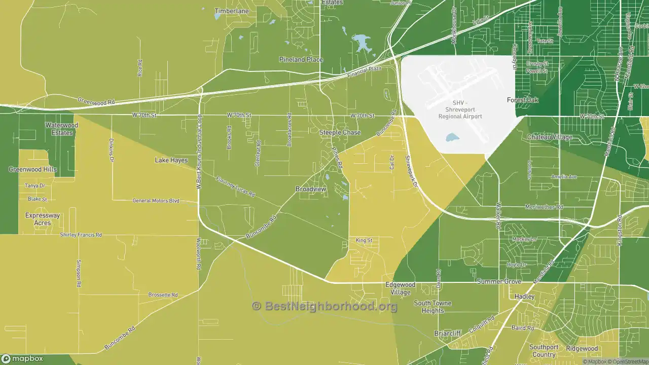
These days, finding an affordable place to live in the Airport-Pines Road area can be challenging. Home prices in Airport-Pines Road are now at a median cost of $196,649, higher than the Shreveport average of $183,019.
The average cost of rent is $849/mo in Airport-Pines Road, primarily driven by the current value of real estate in the Airport-Pines Road area. In Airport-Pines Road, 38.46% of households rent, and 24.82% of homeowners own their homes outright.
Housing affordability isn’t just about home prices, though. The average household income in Airport-Pines Road is $5,171 per month. Households that rent pay about 16.42% of their income on rent here. Airport-Pines Road’s most expensive areas are in the eastern regions, while the cheapest areas are in the central parts of the neighborhood.
Source: BestNeighborhood calculations from the U.S. Census Bureau, American Community Survey (ACS) 2020-2024 5-year estimates.
Nearby Neighborhoods
- Jenkins-Pinecroft, Shreveport, LA: less expensive homes
- Mooretown and Hollywood Heights, Shreveport, LA: less expensive homes
- Western Hills Yarborough, Shreveport, LA: equally priced homes
- Sunset Arcre-Garden Valley-Morningside, Shreveport, LA: less expensive homes
- Hyde Park-Brookwood-Southern Hills, Shreveport, LA: less expensive homes
- Country Club Hills Lakeshore Shops, Shreveport, LA: less expensive homes
- Ceder Grove-Lynbrook, Shreveport, LA: less expensive homes
- Queensborough, Shreveport, LA: less expensive homes
- Caddo Heights-South Highlands, Shreveport, LA: equally priced homes
- Allendale-Lakeside, Shreveport, LA: less expensive homes
Neighborhoods with Similar Populations
- Oceanway, Jacksonville, FL: higher priced homes
- Cathedral Park, Portland, OR: higher priced homes
- Copperfield, Houston, TX: higher priced homes
- McMurray-Huntingdon, Nashville, TN: higher priced homes
- La Homa, Mission, TX: less expensive homes
- Muscoy, San Bernardino, CA: higher priced homes
- Northwest Akron, Akron, OH: higher priced homes
- South 48th Street, Lincoln, NE: equally priced homes
- Shawnee, Louisville, KY: less expensive homes
- Kensington, Buffalo, NY: less expensive homes
No other site shows detail at this level for free. We are able to keep this site free by receiving a small commission from the referring links below if you book, rent, or request a lead at no cost to you. Please share or cite this page if you aren’t able to otherwise support our work.
Map interface © Mapbox © OpenStreetMap Map data and content © bestneighborhood