
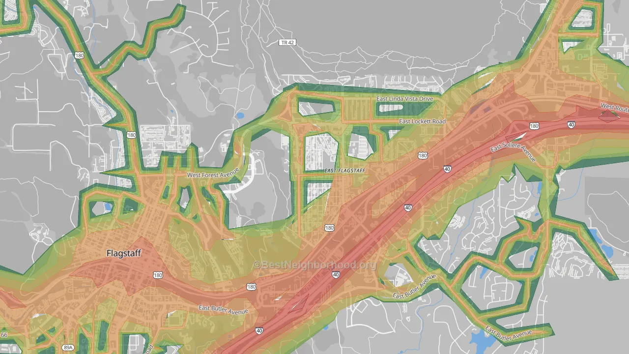
This map shows modeled outdoor noise across Sunnyside-Flagstaff at 100-meter resolution, combining road, aviation, and rail sources. Green areas measure below 45 dBA. Orange and red exceed the EPA's 55 dBA outdoor threshold linked to long-term health effects. Use the layer toggles to view each source on its own or all together.
What the numbers sound like
- 30 dBAWhisper
- 40 dBASoft rainfall
- 45 dBAQuiet suburban street at night
- 50 dBAQuiet office
- 55 dBAEPA outdoor threshold: light traffic 100 ft away
- 60 dBANormal conversation an arm's length away
- 65 dBABusy restaurant
- 70 dBAHighway traffic 50 ft away
- 80 dBACity bus interior
Population Above the EPA Outdoor Threshold
The EPA's 55 dBA outdoor reference level is a common benchmark for residential noise exposure, especially for activity interference, annoyance, and long-term community noise concerns. About 2,646 Sunnyside-Flagstaff residents, or 62.5%, live above that level. By land area, 63.2% of Sunnyside-Flagstaff is above 55 dBA.
See how noise in Sunnyside-Flagstaff compares to similar-sized neighborhoods.
Noise by Part of Sunnyside-Flagstaff
Average noise levels for Sunnyside-Flagstaff residents, grouped by direction from the center of Sunnyside-Flagstaff. The highest population-weighted average is in southern Sunnyside-Flagstaff; the lowest is in central Sunnyside-Flagstaff, where just 55% of residents live in blocks above the EPA's 55 dBA threshold, roughly the same as the share in the loudest section.
Southern Sunnyside-Flagstaff
45% of people above 55 dBA
Northeastern Sunnyside-Flagstaff
59% of people above 55 dBA
Northwestern Sunnyside-Flagstaff
44% of people above 55 dBA
Northern Sunnyside-Flagstaff
53% of people above 55 dBA
Central Sunnyside-Flagstaff
55% of people above 55 dBA
To the human ear, noise in southern Sunnyside-Flagstaff sounds about 151% louder than in central Sunnyside-Flagstaff, a 13.3 dBA gap. Every 10 dBA roughly doubles perceived loudness. Within any of these directions, two homes a quarter mile apart can still differ by 10 or more dBA depending on how close they sit to a major highway.
Rail Noise
Active freight rail runs through parts of Sunnyside-Flagstaff. For most blocks the rail-only contribution is small. Combined road-plus-rail noise rarely exceeds road noise on its own. The exceptions are the handful of blocks within roughly a quarter mile of the right-of-way during pass-through hours.
Use the Rail toggle on the map above to isolate rail's contribution from road and aviation.
How Noise Is Distributed Across Sunnyside-Flagstaff
The bar chart below shows the share of Sunnyside-Flagstaff residents in each noise band. About 31% of residents live below the EPA's 55 dBA threshold, and roughly 6% live in blocks above 60 dBA. Long-term exposure in that range is linked to elevated stress hormones and cardiovascular risk.
How Sunnyside-Flagstaff Compares
Sunnyside-Flagstaff sits the lowest among the peer group. Below: how Sunnyside-Flagstaff's average outdoor noise and share of residents above the EPA threshold compare with Woodlands Village, South Flagstaff, pine-knoll-flagstaff-az, and university-heights-flagstaff-az.
Average noise level (dBA)
Sunnyside-Flagstaff's 55.5 dBA pop-weighted average is the lowest among the peer group. Arizona as a whole averages 53.0 dBA and the U.S. averages 52.0 dBA. Both are lower than Sunnyside-Flagstaff because most of either area is rural land away from major roads.
Share of residents above 55 dBA
About 62.5% of Sunnyside-Flagstaff residents live in blocks where outdoor levels exceed the EPA's 55 dBA threshold. That's in the middle of its peer group. Measured by land area instead, 63.2% of Sunnyside-Flagstaff's footprint sits above 55 dBA, against a Arizona average of 28.3% and a national average of 28.1%.
What This Means if You're Moving to Sunnyside-Flagstaff
- Distance from highways matters more than the neighborhood name. Two homes in the same zip code can differ by 20 dBA if one sits 100 meters from ~~sb040~~~~~~~~~~~~~~~~~~~~~~~~~ and the other 500 meters away. The model captures this at 100-meter resolution, so noise exposure changes block by block.
- Tree canopy can help reduce modeled noise exposure. Roughly 16% of Sunnyside-Flagstaff is under tree cover (about average for neighborhoods), and the dominant land cover is low-intensity developed land. Both are measured from federal USDA Forest Service and USGS satellite imagery at 30-meter resolution. Streets with 60% or higher canopy show 3 to 5 dBA lower noise than comparable streets with bare ground or pavement, which is why the per-place decay rate above already accounts for it.
Sources & Methodology
The BestNeighborhood noise model is calibrated against nearly one million federal ground-truth measurements across four states. Road noise is computed from segment-level federal traffic data and propagated outward using physics-based acoustic decay, with attenuation rates that depend on the surrounding land cover.
Federal datasets used:
FHWA Highway Performance Monitoring System: road geometry, traffic counts, lane configuration
U.S. DoT Bureau of Transportation Statistics National Transportation Noise Map: aviation and rail noise, road calibration ground truth
USGS / MRLC National Land Cover Database: land cover and impervious surface coverage
USDA Forest Service Tree Canopy Cover: vegetation density for sound propagation
U.S. Census Bureau TIGER/Line: block-level geography and population
U.S. EPA Levels Document: 55 dBA outdoor reference level
All inputs are published federal datasets. Block-level noise is computed by combining road, rail, and aviation sound sources in the energy domain, the same physics used in professional environmental noise assessments. Read the full methodology.