
Population 4,419 · Census ACS 2020–24
Choose a measure to map it.Tap a measure to map it. Swipe the row for more. Arrows show the change since 2006–10.
Median age by neighborhoodHistory and comparison ↓︎
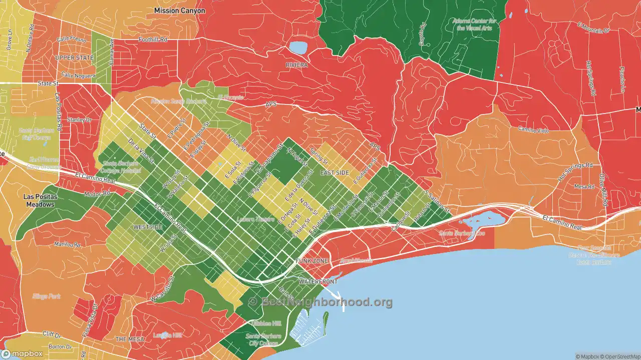
Younger residents
Older residents
Colorblind friendly
off
More maps of Lower East: Best Neighborhoods · Walk Grade · Household income · Home prices · Race · Politics · Traffic noise · Internet
Population and households in Lower East
Household size in Lower East
| Period | Lower East | Santa Barbara | California | U.S. |
|---|---|---|---|---|
| 2006–10 | 2.80 | 2.52 | 3.04 | 2.68 |
| 2010–14 | 2.41 | 2.68 | 3.10 | 2.73 |
| 2015–19 | 2.54 | 2.57 | 3.09 | 2.71 |
| 2020–24 | 2.70 | 2.52 | 3.01 | 2.65 |
| Change | −0.10 | −0.01 | −0.03 | −0.03 |
At 2.70 people per household, Lower East sits close to the national average of 2.65. The typical household here is bigger than in Santa Barbara overall, where it has 2.52 people. Since 2006–10, household size has dropped from 2.80, but in a place this small, much of that may be survey noise rather than real change.
Household size: the average number of people living in each occupied home. Source: BestNeighborhood calculations from U.S. Census Bureau ACS 5-year block-group estimates (table B25010).
Median age in Lower East
| Period | Lower East | Santa Barbara | California | U.S. |
|---|---|---|---|---|
| 2006–10 | 37.7 | 41.5 | 35.8 | 37.7 |
| 2010–14 | 39.9 | 41.3 | 36.8 | 38.6 |
| 2015–19 | 39.2 | 42.5 | 37.9 | 39.6 |
| 2020–24 | 37.1 | 43.5 | 39.0 | 40.1 |
| Change | −0.6 | +2.0 | +3.1 | +2.3 |
The median resident of Lower East is 37.1 years old, a few years younger than the national median of 40.1.
Median age: the age that splits residents into two equal halves. Source: BestNeighborhood calculations from U.S. Census Bureau ACS 5-year block-group estimates (table B01002).
Single-parent households in Lower East
| Period | Lower East | Santa Barbara | California | U.S. |
|---|---|---|---|---|
| 2006–10 | 12.1% | 9.2% | 13.5% | 12.3% |
| 2010–14 | 17.1% | 9.7% | 13.5% | 12.3% |
| 2015–19 | 15.0% | 9.1% | 12.3% | 11.6% |
| 2020–24 | 12.6% | 10.3% | 12.3% | 11.6% |
| Change | +0.5 pts | +1.1 pts | −1.2 pts | −0.6 pts |
Single parents head about one in eight households in Lower East (12.6%), close to the national share of 11.6%. Single parents are more common here than in Santa Barbara as a whole (10.3%).
Single-parent households: households where one adult with no spouse present lives with children under 18. Source: BestNeighborhood calculations from U.S. Census Bureau ACS 5-year block-group estimates (table B11003).
Housing in Lower East
Renters in Lower East
| Period | Lower East | Santa Barbara | California | U.S. |
|---|---|---|---|---|
| 2006–10 | 68.5% | 48.6% | 42.6% | 33.3% |
| 2010–14 | 69.8% | 50.5% | 45.2% | 35.6% |
| 2015–19 | 65.9% | 50.8% | 45.2% | 36.0% |
| 2020–24 | 70.0% | 52.1% | 44.1% | 34.8% |
| Change | +1.5 pts | +3.6 pts | +1.5 pts | +1.5 pts |
Most households in Lower East rent: 70.0% of occupied homes are rented, far above the national share of 34.8%. Expect more apartments, and more turnover, than in owner-heavy areas. Among homeowners, 38.4% have no mortgage at all, about the same as nationally.
Renters: occupied homes that are rented rather than owned. Source: BestNeighborhood calculations from U.S. Census Bureau ACS 5-year block-group estimates (table B25003).
Vacant homes in Lower East
| Period | Lower East | Santa Barbara | California | U.S. |
|---|---|---|---|---|
| 2006–10 | 9.8% | 8.4% | 8.7% | 11.4% |
| 2010–14 | 8.3% | 8.9% | 8.1% | 11.4% |
| 2015–19 | 6.3% | 7.7% | 7.5% | 11.1% |
| 2020–24 | 4.8% | 7.7% | 7.3% | 9.6% |
| Change | −5.0 pts | −0.7 pts | −1.4 pts | −1.8 pts |
Empty homes are scarce in Lower East: just 4.8% sit vacant, compared with 9.6% nationally, a sign of a tight housing market.
Vacant homes: homes with no one living in them, including vacation homes and homes for sale or rent. Source: BestNeighborhood calculations from U.S. Census Bureau ACS 5-year block-group estimates (table B25002).
Age of homes in Lower East
| Period | Lower East | Santa Barbara | California | U.S. |
|---|---|---|---|---|
| 2006–10 | 1954 | 1962 | 1972 | 1974 |
| 2010–14 | 1955 | 1964 | 1973 | 1975 |
| 2015–19 | 1963 | 1964 | 1974 | 1977 |
| 2020–24 | 1962 | 1966 | 1976 | 1980 |
| Change | +8 | +3 | +4 | +6 |
Lower East is a place of older homes: half were built before 1962, while the national median is 1980. That means established neighborhoods, and more houses that may need updating. The picture is much the same across Santa Barbara.
Age of homes: the year that splits the housing stock into older and newer halves. Source: BestNeighborhood calculations from U.S. Census Bureau ACS 5-year block-group estimates (table B25035).
Rent in Lower East
| Period | Lower East | Santa Barbara | California | U.S. |
|---|---|---|---|---|
| 2006–10 | $1,294 | $1,544 | $1,298 | $965 |
| 2010–14 | $1,157 | $1,642 | $1,379 | $1,040 |
| 2015–19 | $1,759 | $2,088 | $1,721 | $1,213 |
| 2020–24 | $2,351 | $2,707 | $2,229 | $1,571 |
| Change | +$1,056 | +$1,163 | +$931 | +$606 |
Rent in Lower East runs $2,351 a month at the median, utilities included, well above the U.S. median of $1,571. Still, rents here are lower than in Santa Barbara as a whole ($2,707). The typical renter here spends 30.8% of household income on rent, just over the 30% mark often used to define affordable rent.
Rent: monthly rent plus the utilities renters pay themselves. Source: BestNeighborhood calculations from U.S. Census Bureau ACS 5-year block-group estimates (table B25064).
Education in Lower East
Bachelor's degrees in Lower East
| Period | Lower East | Santa Barbara | California | U.S. |
|---|---|---|---|---|
| 2006–10 | 25.9% | 43.1% | 29.1% | 28.4% |
| 2010–14 | 25.3% | 44.6% | 30.1% | 29.6% |
| 2015–19 | 34.7% | 49.1% | 32.9% | 32.1% |
| 2020–24 | 36.7% | 51.6% | 36.3% | 35.6% |
| Change | +10.8 pts | +8.5 pts | +7.1 pts | +7.2 pts |
College degrees are about as common in Lower East as nationally: 36.7% of adults 25 and older have a bachelor's or higher, against 35.6%. The share is lower than in Santa Barbara as a whole (51.6%).
Bachelor's degrees: adults 25 and older with a bachelor's degree or higher. Source: BestNeighborhood calculations from U.S. Census Bureau ACS 5-year block-group estimates (table B15003).
High school graduates in Lower East
| Period | Lower East | Santa Barbara | California | U.S. |
|---|---|---|---|---|
| 2006–10 | 67.0% | 85.5% | 79.9% | 84.9% |
| 2010–14 | 71.3% | 85.5% | 80.7% | 86.1% |
| 2015–19 | 75.0% | 87.5% | 82.6% | 87.7% |
| 2020–24 | 80.2% | 89.6% | 84.2% | 89.3% |
| Change | +13.3 pts | +4.1 pts | +4.3 pts | +4.3 pts |
About one in five adults in Lower East never finished high school, well above the national share: only 80.2% have a diploma or equivalent, against 89.3% nationally.
High school graduates: adults 25 and older with a high school diploma, GED or more. Source: BestNeighborhood calculations from U.S. Census Bureau ACS 5-year block-group estimates (table B15003).
Jobs in Lower East
| Period | Lower East | Santa Barbara | California | U.S. |
|---|---|---|---|---|
| 2006–10 | 7.2% | 6.1% | 9.2% | 8.1% |
| 2010–14 | 10.3% | 6.9% | 11.3% | 9.4% |
| 2015–19 | 3.7% | 3.7% | 6.3% | 5.6% |
| 2020–24 | 5.0% | 5.2% | 6.6% | 5.4% |
| Change | −2.3 pts | −0.9 pts | −2.6 pts | −2.7 pts |
At 5.0%, unemployment in Lower East is close to the national rate of 5.4%. Because the Census pools five years of responses (2020–24), these rates smooth over short swings and lag the current job market.
Unemployment: people looking for work as a share of everyone working or looking. Source: BestNeighborhood calculations from U.S. Census Bureau ACS 5-year block-group estimates (table B23025).
Lower East compared with nearby neighborhoods
| Neighborhood | Household size | Median age | Single parents | Renters | Vacant homes | Median year built | Median rent | Bachelor's degree | High school diploma | Unemployment |
|---|---|---|---|---|---|---|---|---|---|---|
| Lower East | 2.70 | 37.1 | 12.6% | 70.0% | 4.8% | 1962 | $2,351 | 36.7% | 80.2% | 5.0% |
| Eastside Santa Barbara | 2.99 | 41.0 | 15.0% | 56.3% | 1.6% | 1951 | $2,712 | 30.9% | 79.7% | 5.9% |
| Waterfront | 2.04 | 39.1 | 15.2% | 80.7% | 10.1% | 1968 | $2,504 | 48.3% | 90.0% | 5.6% |
| Riviera | 2.43 | 46.1 | 7.3% | 35.6% | 8.1% | 1963 | $2,675 | 62.6% | 92.6% | 2.7% |
| Westside-Santa Barbara | 2.69 | 34.6 | 15.7% | 75.4% | 7.8% | 1965 | $2,384 | 38.6% | 80.2% | 7.8% |
| Mesa | 2.38 | 47.9 | 8.7% | 40.6% | 7.8% | 1964 | $2,812 | 61.0% | 96.2% | 6.3% |
| Las Positas | 2.53 | 52.4 | 3.6% | 34.8% | 12.4% | 1968 | $3,292 | 60.0% | 94.7% | 3.8% |
| Upper State | 2.31 | 48.3 | 6.3% | 47.4% | 9.3% | 1966 | $2,662 | 59.0% | 93.9% | 5.1% |
| Sea View Estates | 3.87 | 30.8 | 27.4% | 31.6% | 6.6% | 1982 | $1,907 | 25.0% | 78.9% | 5.7% |
| Sierra Linda | 4.07 | 29.1 | 25.5% | 62.5% | 4.2% | 1970 | $1,897 | 10.0% | 67.5% | 8.7% |
| South Bank | 3.47 | 33.0 | 12.9% | 54.5% | 2.7% | 1989 | $2,353 | 26.1% | 69.3% | 7.3% |
All figures 2020–24.
Neighborhoods with similar populations: Questa, Mountain House, CA · Mt Ivy, Pomona, NY · Western Hills, Beaumont, TX · Maple Heights-Lake Desire, Renton, WA · Kingsland, Lyndhurst, NJ · Arctic, West Warwick, RI · Alban Hills, Albuquerque, NM · Garden Springs, Lexington, KY · Woodside Village, Largo, FL · Schenley, Youngstown, OH
About these numbers
Every figure on this page is a BestNeighborhood calculation from the Census Bureau's American Community Survey (ACS), built up from the Census block groups that make up Lower East. Each ACS 5-year release pools five years of responses; this page shows the last 15 releases, 2006–10 through 2020–24. Neighboring releases share four of their five years, so they move gradually and small changes between them are within the survey's margin of error; in small places the lines can jump from one release to the next for the same reason. The maps show the same measures for each neighborhood, ranked against the whole country.
No other site shows detail at this level for free. We are able to keep this site free by receiving a small commission from the referring links on this page. Please share or cite this page if you aren’t able to otherwise support our work.