
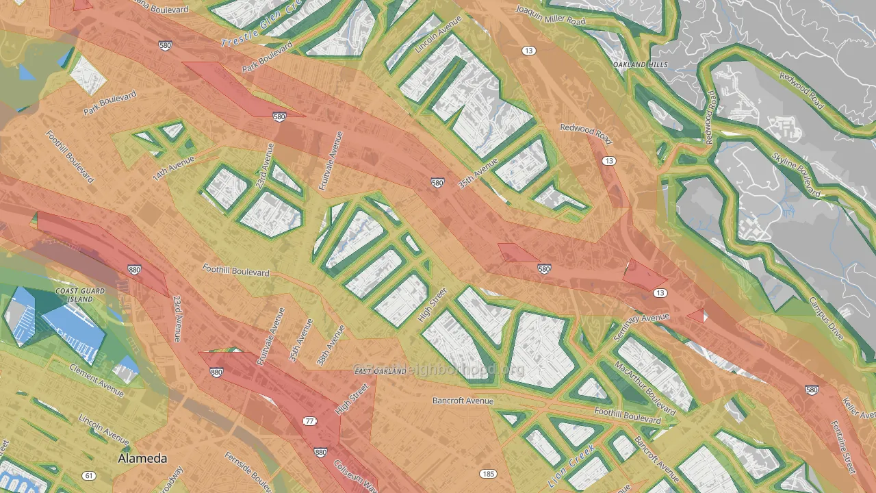
This map shows modeled outdoor noise across Allendale at 100-meter resolution, combining road, aviation, and rail sources. Green areas measure below 45 dBA. Orange and red exceed the EPA's 55 dBA outdoor threshold linked to long-term health effects. Use the layer toggles to view each source on its own or all together.
What the numbers sound like
- 30 dBAWhisper
- 40 dBASoft rainfall
- 45 dBAQuiet suburban street at night
- 50 dBAQuiet office
- 55 dBAEPA outdoor threshold: light traffic 100 ft away
- 60 dBANormal conversation an arm's length away
- 65 dBABusy restaurant
- 70 dBAHighway traffic 50 ft away
- 80 dBACity bus interior
Population Above the EPA Outdoor Threshold
The EPA's 55 dBA outdoor reference level is a common benchmark for residential noise exposure, especially for activity interference, annoyance, and long-term community noise concerns. About 1,359 Allendale residents, or 43.2%, live above that level. By land area, 52.6% of Allendale is above 55 dBA.
See how noise in Allendale compares to similar-sized neighborhoods.
Airport Noise
San Francisco Bay Oakland International (OAK), a commercial airport, lies south of the center of Allendale. Use the Aviation toggle on the map above to see where its modeled noise reaches.
Aviation noise on the map comes from the U.S. Department of Transportation's National Transportation Noise Map, which models noise around the airports it covers. For airports outside that map, BestNeighborhood estimates noise from FAA traffic counts and runway layout, and keeps that estimate on the low side.
How Noise Is Distributed Across Allendale
The bar chart below shows the share of Allendale residents in each noise band. About 45% of residents live below the EPA's 55 dBA threshold, and roughly 0% live in blocks above 60 dBA. A systematic review for the World Health Organization's 2018 Environmental Noise Guidelines found that the risk of ischemic heart disease rises about 8% for every 10 dB increase in long-term road traffic noise.
How Allendale Compares
Allendale sits the lowest among the peer group. Below: how Allendale's average outdoor noise and share of residents above the EPA threshold compare with Upper Dimond, Upper Laurel, Rancho San Antonio, and maxwell-park-oakland-ca.
Average noise level (dBA)
Allendale's 54.8 dBA pop-weighted average is the lowest among the peer group. California as a whole averages 54.0 dBA, and the U.S. averages 52.0 dBA.
Share of residents above 55 dBA
About 43.2% of Allendale residents live in blocks where outdoor levels exceed the EPA's 55 dBA threshold. That's fewer than any of its peer group. Measured by land area instead, 52.6% of Allendale's footprint sits above 55 dBA, against a California average of 36.0% and a national average of 28.1%.
What This Means if You're Moving to Allendale
- Distance from major roads matters more than the neighborhood name. Two homes in the same ZIP code can differ by more than 15 dBA when one sits 100 meters from a highway and the other 500 meters away. The model works at 100-meter resolution, so noise exposure changes block by block.
- Land cover sets how fast noise fades in the model. About 4% of Allendale is under tree canopy, lighter than most neighborhoods, and about 59% is impervious surface such as pavement and rooftops. Its most common land cover is medium-intensity developed land. These figures come from USDA Forest Service and USGS satellite data at 30-meter resolution, and the model uses them to set the rate at which noise fades with distance in Allendale.
- Airport noise follows the flight paths. Aviation noise concentrates under San Francisco Bay Oakland International's approach and departure paths, so two homes the same distance from its runways can hear different levels. The Aviation layer on the map shows its modeled footprint.
Sources & Methodology
The BestNeighborhood noise model is calibrated against nearly one million federal ground-truth measurements across four states. Road noise is computed from segment-level federal traffic data and propagated outward using physics-based acoustic decay, with attenuation rates that depend on the surrounding land cover.
Federal datasets used:
FHWA Highway Performance Monitoring System: road geometry, traffic counts, lane configuration
U.S. DoT Bureau of Transportation Statistics National Transportation Noise Map: aviation and rail noise, road calibration ground truth
USGS / MRLC National Land Cover Database: land cover and impervious surface coverage
USDA Forest Service Tree Canopy Cover: vegetation density for sound propagation
U.S. Census Bureau TIGER/Line: block-level geography and population
U.S. EPA Levels Document: 55 dBA outdoor reference level
Health research cited:
World Health Organization Environmental Noise Guidelines systematic review (2018): road traffic noise and heart disease
All inputs are published federal datasets. Block-level noise is computed by combining road, rail, and aviation sound sources in the energy domain, the same physics used in professional environmental noise assessments. Read the full methodology.